FAQ
All you need to know about the Penang Transport Master Plan project
1.What is the Penang Transport Master Plan?
PTMP is the key solution to meet the expected increase in travel demand in Penang over the next 50 years (2015-2065) as a result of higher employment and investments, population growth and the booming tourism industry.
2.What are the benefits of PTMP?
PTMP will reduce:
- Reduce major traffic issues in Penang;
- Lower travel expenses;
- Reduce journey times;
- Create job opportunities; and
- Provide various modes of transport.
Without improvements to the current public transport infrastructure, road congestion will continue to deteriorate as Penang’s population increases. This will impact travel time and the overall quality of life in Penang.
3.Will the heritage sites in Penang be affected by the construction of the PTMP?
No, it will not. The Penang State Government recognises and values the importance of World Heritage Sites. To ensure the conservation of the architecture, culture and cityscape of the buildings in the George Town World Heritage Site, the proposed Bayan Lepas LRT and future transit lines will be aligned accordingly around the perimeter of the heritage site and buffer zone. In compliance with the heritage guidelines, the tram line within the World Heritage Site will be at-grade (on ground).
What are the components proposed under the PTMP?
The PTMP comprises a public transport network, highways and roads that will be integrated with various modes of existing transport to serve the needs of the future population and support Penang’s economic growth over the coming decades.
Phase 1 of the PTMP will include the Bayan Lepas LRT, the Pan Island Link (PIL) 1 as well as the Penang South Reclamation.
When is construction scheduled to begin and will it be done simultaneously?
The Bayan Lepas LRT and PIL 1 are deemed as priority projects and thus major works are targeted to commence by Q3 of 2020.
What is the total cost of the project?
The initial cost has been estimated at RM27 billion. However, the actual cost will only be known once the PDP undertakes a detailed design and completes the tender process.
How will the project be funded?
PTMP projects are proposed to be financed by the sale of reclaimed islands along the southern coast of Penang Island. The Penang State Government claims full ownership of the reclaimed land and will carry out tenders to sell the land in the open market.
How will the proposed transport network improve connectivity?
The PTMP outlines a collective and holistic transport network that aims to improve integration with existing and future infrastructure as well as developments that are underway while incorporating a clear hierarchical approach in terms of delivery.
The identified corridors in the proposed projects will result in comprehensive transport coverage across both the island and the mainland. Among key considerations made in the proposed transport network are critical high-density residential, employment and commercial areas to ensure the highest catchment and ridership.
Importantly, while mass rail transit will form the major backbone for public transport in Penang in the coming decades, it will be well supported by a strong network of feeder buses to improve accessibility within the immediate catchment area of the respective stations.
How many property acquisitions will take place?
Studies are currently being conducted to identify the amount of property lots and tenants whose properties will be needed for this project. We will work closely, sensitively, and respectfully with all affected tenants and property owners throughout the acquisition process.
We will also be engaging with people whose properties will not be required for the project, but will be affected by its construction.
What is the tender process for work package contractors?
In line with the procurement guidelines, a competitive tender process will be carried out in an objective and transparent manner.
1.Why was the LRT chosen over other modes of transport such as tram and BRT?
The LRT does not disrupt road traffic as compared to at-grade trams and BRT, which take up road space. This means the LRT has no risk of colliding with people, vehicles and buildings. Widening roads for dedicated tram, BRT lanes and stations require land acquisition, which will lead to high social impact to the public. The cost for land acquisition is minimal for elevated LRTs. As land is scarce on the island, the LRT will be the most practical and cost-effective solution.
2.Will there be any Park & Ride stations along the LRT route?
There are eight stations currently in planning to be equipped with Park & Ride facilities.
3.How can I share feedback or concerns about the construction activities and / or workers (contractor parking inconveniences, dust, noise etc)?
Any complaint can be channelled through the project hotline, the official project website or by walking into the project office. The hotline and official website will be established and announced once the project has started.
Will the LRT alignment affect the expansion of the Penang International Airport?
On the contrary, the LRT alignment will be integrated with the future expansion plans of the Penang International Airport. Among the facilities that could be expanded include the main terminal, training centre, multi-storey car park and the new low-cost carrier terminal.
When is construction slated to begin and when will the LRT be in operation?
The construction of the Bayan Lepas LRT is targeted to commence in Q3 2020 while operations are expected to start in Q4 2026.
The proposed LRT alignment will traverse through many schools. What measures will be put in place to safeguard children and parents during construction?
Construction of the LRT will not compromise the safety of the public. Discussions with the schools will be conducted and a dedicated TMP will be implemented for each school to comply to safety procedures.
Proper hoardings will be erected to prevent children from encroaching into the work areas. Machinery movement will be properly controlled, especially during drop-off and pick-up times.
Existing entrances will not be blocked and the movement of students will not be disrupted by any construction activities. Walkways and pedestrian crossings will be maintained.
The LRT alignment partially encroaches the cycling paths at some spots. Is it safe to ride under the structure during construction?
Access to the cycling paths will be maintained during construction period. Several cycling paths stretching along the LCE have been identified as being affected by the construction of LRT structures. These sections will be realigned prior to the construction work with proper concrete barricades to ensure safety to cyclists.
Why was the LRT chosen over other modes of transport such as tram or BRT?
LRT does not disrupt road traffic as compared to at-grade trams and BR Ts which take up road space. This means LRT has no risk of colliding with people, vehicles and buildings. Also to widen roads for dedicated tram and BRT lanes and stations require land acquisition which will lead to high social impact to the public. The cost for land acquisation is minimal for elevated LRTs. As land in scarce on the the island, the LRTwould be the most practical and cost effective solution.
How can I share feedback or concerns about construction activities and/or workers (contractor parking inconveniences, dust, noise, etc)?
Any complaint can be channeled through the project hotline, the official project website or by walking in to the project office. The hotline and official website will be established and announced once the project has started.
Will there be any Park & Ride stations along the LRT route?
There are eight stations currently in planning to be equipped with Park & Ride facilities.
1.What are the benefits of PIL 1 to the public?
Penang is now served by only one spine road – the Tun Dr Lim Chong Eu Expressway (LCE). PIL 1 is meant to serve as a second spine and a second spine and a new bypass functioning as a traffic dispersal system with six strategic interchanges connecting Gurney Expressway, Jalan Paya Terubong, Jalan Tun Dr Awang, LCE and the first and second Penang Bridges. In summary, PIL 1 is meant to be an alternative to the LCE. PIL 1 will ultimately disperse traffic from the LCE, allowing for better traffic flow for both private and public transports.
2.What is the solution taken to preserve historical such as Bukit Bendera and Kek Lok Si Temple?
In line with the Penang Hill Special Area Plan (SAP) and to preserve the beauty and serenity of the hill, PIL 1 will consist of tunnels within the SAP’s boundary. As for Kek Lok Si, PIL 1’s alignment is located about 500m away from the temple, a more than safe distance for the highway’s construction.
3.What kind of safety measures will be in place for nearby residential areas?
Both the Environmental Department and Mineral and Geosciences Department have set guidelines for allowable vibration due to controlled blasting works in sensitive areas. The blast design will be developed in line with the allowable limits. Trial blasts will be done before actual work begins to ensure full compliance with the relevant guidelines.
The LCE Expressway experienced congestion not long after it was constructed. Will PIL 1 face a similar situation? How long can PIL 1 sustain traffic flow without being congested?
The LCE Expressway is not a highway with controlled access. There are numerous entry/exit points along the alignment as this is the only spine road connecting the north of the island to the south. Being underground and elevated, PIL 1 will be access controlled to cater for future traffic growth.
What tunnelling method will be used for construction of PIL 1?
The drill and controlled blast method will be used. This method is most commonly used for tunnelling through granite and has been adopted in Malaysia since the 1970s, including the Genting Sempah Tunnel (Karak Expressway) and Menora Tunnel (North South Expressway).
It is a safe and established method that takes into consideration all aspects related to ground movement and settlement.
What safety measures will be put in place for blasting works adjacent to residential areas?
Both the Department of Environment (DoE) and the Department of Mineral and Geoscience (DoMG) have set guidelines on the allowable vibration at sensitive spots such as residential areas due to controlled blasting works.
Blasts will be conducted in line with the allowable limits and trial blasts will be carried out before actual works begin to ensure full compliance to relevant guidelines.
Part of the PIL 1 alignment is to be constructed along a river reserve. What methods and measures are in place to protect the river during and after construction?
In line with DoE guidelines, the Land Disturbance Pollution Prevention & Mitigation Measures (LDP2M2) plan will be developed during the detailed design stage for approval.
In this plan, details of mitigation measures such as check dams, silt traps, silt fences, sand bag perimeter bunds etc will be designed to ensure existing rivers are not negatively affected. Besides this, the Environmental Management Plan (EMP) will also be submitted to the DoE prior to construction.
The EMP entails the type and frequency of tests to be carried out during the construction period. All test reports will need to be submitted to the DoE periodically.
What are the safety measures that need to be complied with to store and transport the explosives used during tunnelling?
Any storage of explosive material will be subject to approval by Polis Diraja Malaysia (PDRM) in compliance to stringent requirements with regards to safety and suitability of the proposed locations.
Basic requirements include a minimum distance of 500 metres from any residence as well as armed security. The explosive material will be transported in small quantities to the site daily and any unused material for the day must be returned to the bunker.
What is being done to preserve historical locations such as Bukit Bendera and the Kek Lok Si Temple?
In line with the Penang Hill Special Area Plan (SAP), PIL 1 will be fully tunnelled within the SAP boundary. This ensures that the beauty and serenity of Penang Hill is preserved. As for the Kek Lok Si Temple, the alignment is approximately 500 metres away from the temple and thus unaffected by the presence of PIL 1.
What are the benefits of PIL 1 to the public?
Currently, Penang is served by only one spine road which is the already congested Tun Dr Lim Chong Eu (LCE) Expressway.
PIL 1 is meant to serve as a second spine and a new bypass functioning as a traffic dispersal system with six strategic interchanges connecting Gurney Expressway, Jalan Paya Terubong, Jalan Tun Dr Awang, LCE and the First and Second Penang Bridges. In summary, PIL 1 is meant to be an alternative to the LCE. PIL 1 will ultimately disperse traffic from the LCE, allowing for better traffic flow for both private and public transports.
What is the solution taken to preserve historical locations such as Bukit Bendera and Kek Lok Si temple?
In line with the Penang Hill special area plan, the PIL 1 Highway will be consist of tunnels within the special area plan boundary. This ensures the beauty and serenity of Penang Hill is preserved.
As for the Kek Lok Si temple, the alignment is situated appoximately 500m away, a more than safe distance for PIL 1 to be constructed.
What kind of safety measures for blasting works are in place for the adjacent residential areas?
Both the Department of Environment and the Department of Mineral and Geoscience have set guidelines on the allowable vibration at sensitive areas due to controlled blasting works.
The blast design will be developed in line with the allowable limits and trial blasts will be carried out before actual work begins to ensure full compliance to the relevant guidelines.
1. The PMRT projects proposed are revival of the Penang Outer Ring Road (PORR) project, which were opposed by the people of Penang. Why should Penangites now have to support this project?
The Penang Outer Ring Road (PORR) and the PMRT Project are not exactly the same, though have similar goals to alleviate traffic congestion.
Package 1 and Package 2 have similar alignment to PORR. However, Package 3 is an entirely new alignment that connects to the proposed Third Link Project from Gurney Drive to Bagan Ajam.
The Penangites should support the project based on the following: –
- The Three Major Roads Project is toll-free, whereas the PORR Project is tolled.
- Traffic congestion in Penang Island, Penang bridge and roads leading to the Penang Airport has reached saturated flow (Level of Service F) during peak hours, rainy days, vehicle accidents, festive seasons etc.
- Package 3 (which is not in the PORR network) provides a solution to traffic congestion at several major roads critical junction and adjoining street, which shall play a major role in traffic dispersal for the island. Furthermore, Package 3 will provide an uninterrupted traffic flow for the Island to the Mainland and vice versa.
- The Third Link which is connected to Package 3 shall create new economic growth centres in the Mainland.
- The 3 Major Road is part of the Penang Transport Master Plan (PTMP), which is a necessary for the sustenance of a balanced economic development for the State Government with minimal social and environmental impact.
2. When can the project commence?
Subject to some key project milestones being completed, we are confident that the project shall commence with Package 2 (Bandar Baru Ayer Itam to Lebuhraya Tun Dr. Lim Chong Eu By-pass), targeted to start by end quarter 2020.
3. Which work package will commence first?
Package 2 (Bandar Baru Ayer Itam to Lebuhraya Tun Dr. Lim Chong Eu By-pass) shall commence first, targeted to start by end quarter 2020. The commencement of Package 1, Package 3 and Third Link will be decided at a later date.
4. Do the Penang Three Major Roads a comprehensive and rational transport strategy for Penang? Why?
The Penang Three Major Roads project is outlined in the Penang Transport Master Plan (PTMP) 2013-2030. These major roads are sub components of the overall implementation of the PTMP.
5. Is the “Request for Proposal” (RFP) method used by the State Government of Penang to award the PMRT project to Consortium Zenith Construction Sdn Bhd (CZCSB), considered as open tender?
Yes. The Penang State Government awarded the contract to CZCSB through the process of Request for Proposal (RFP) by an open tender. There were three stages in the process of selecting and awarding the PMRT Project as follows:
- Pre-Qualification Process
- Request for Proposal (RFP)
- Tender Award Process
- Letter of Intent (LOI)
- Preliminary Agreement
At the Pre-Qualification Process, 60 companies attended the exercise and a total of 11 proposals were received. All tenderers had gone through 3 stages of screening i.e. Preliminary Screening, Technical Screening and Financial Screening. After all screenings had been done, only 8 out 11 companies succeeded in the Pre-Qualification Process and were invited to submit the proposal. From the 8 companies, only 5 tenderers had submitted their proposal to the Penang State Government i.e. IJM-CRGL JV, WCT Berhad–Daewoo JV, ECK Construction Sdn. Bhd., Consortium Zenith BUCG Sdn. Bhd. and VST Cemerlang Sdn. Bhd–China State Co JV.
Through an overall evaluation on the financial and technical submissions, the ‘Jawatankuasa Teknikal dan Kewangan’ had recommended CZCSB to the Penang State Tender Board based on the lowest cost received including fulfillment of technical expertise and financial capability.
Subsequently, through a Letter of Intent (LOI), the Penang State Government expressed the intention to appoint CZCSB to undertake the project. CZCSB’s initial offer was to undertake the project with 157 acres of land to be alienated to them. After negotiating with CZCSB, the Penang State Government reduced the land swap acreage to 110 acres without any changes to the overall implementation cost of the project. The Preliminary Agreement was subsequently signed on 6th October 2013.
6. Do you think that instead of constructing the third link, upgrading the ferry serviced would be a better way to deal with the cross-channel traffic issues? Why?
In the Penang Transport Master Plan (PTMP), the State has identified the need to upgrade the current ferry service between Butterworth and Georgetown with aims to deal with the cross-channel issues. The strategy is to introduce: –
- Butterworth and Gurney Quay
- Butterworth and Queensbay
- Straits Quay, Tanjong Tokong Island, Gurney Quay, Weld Quay, The Light and Queensbay.
To deal with the cross-channel traffic growth, upgrading the ferry service is inadequate to cater for high demand of cross channel traffic. Indicatively, the Penang bridge capacity has reached its saturated level of service during peak hours, public holidays and also when there are accidents on the bridge. This project is needed to compliment and alleviate high demand of cross channel traffic for the future.
There is NO efficient and cost-effective ferry service, ferry service has always been a temporary and alternative service link. Penang needs a Third Link, either a tunnel or a bridge. A tunnel cost the least environmental impact. Driving through underwater tunnel save time. Time is money. Means save cost in the long run. Ferry polluted the air too as they use fuel.
7. Some group feel that they are all for public transportation but it need not be mega projects. Do you think that the PMRT project would be a comprehensive system which is seamless and accessible?
Yes, it is seamless and accessible because this is to meet the policies outlined in the Penang Structure Plan with the ultimate aim to ease traffic congestion in Penang, a study known as Penang Transport Master Plan (PTMP) has also been undertaken by the Penang State Government and the NCIA (North Corridor Implementation Authority) to develop a sustainable transport master plan strategy with the following aims: –
- To adopt a holistic approach to resolve the transportation issues;
- To make roads safe for all users;
- To move towards a private vehicle to public transport modal split rating of 40:60; and
- To ensure integrated between the transport and traffic system between Penang Island and the Mainland.
8. Explain how each of the Penang Major Roads (Package 1, 2 & 3) is able to create traffic dispersal?
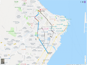
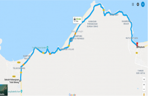
Package 1 serves an alternative road from Tanjong Bungah to Teluk Bahang. Presently, by using the current road, the travelling time and length from Sekolah Kebangsaan Teluk Bahang to Maybank Jalan Lembah Permai is 21 minutes and 11.2km but if using Package 1 highway, it will only take 7 minutes and 10.57km with a constant 90kph to reach the destination. And this is non-peak hours basis and it will take much longer time during peak hours.
Currently, there is no alternative route if the existing road is closed due to unforeseen circumstances such as landslides and major accidents causing total closure of the road. The current narrow and winding road create massive congestion during peak hours and weekends. Therefore, this Package 1 serves as an alternative road to by-pass the existing road. With the introduction of the link from Lembah Permai to Gurney Coastal Road, it will ensure a safer, faster and more efficient flow of traffic from Teluk Bahang, Batu Feringghi and Tanjong Bungah to the city center.
Package 2 serves as a by-pass as the name suggest from Lebuhraya Tun Dr. Lim Chong Eu to Ayer Itam. Currently, if we were to go to Lebuhraya Tun Dr. Lim Chong Eu from Farlim, Ayer Itam , we have to travel from Jalan Thean Tiek and turn in to Jalan Masjid Negeri and subsequently to Jalan Tunku Kudin and lastly connect to Lebuhraya Tun Dr. Lim Chong Eu. The length of this route is 6.7km and it takes about 15 minutes of travelling time. Presently, if we were to travel from Farlim to Mutiara Ria at Jalan Bukit Gambir, we need to travel from Jalan Thean Teik and turn to Jalan Masjid Negeri and go through Jalan Yeap Chor Ee and subsequently to Jalan Bukit Gambir and reach Mutiara Ria where it takes about 15 minutes to travel through a 6.2km route. Another example, if we were to travel from Farlim to Jalan Sultan Azlan Shah, we will have to travel from Jalan Thean Tiek and turn in to Lorong Batu Lanchang and Jalan Masjid Negeri and subsequently to Jalan Sultan Azlan Shah in 14 minutes for a length of 5.6km route. If we were to use the Major Road 2 highway from Mutiara Ria in Jalan Bukit Gambir to Jalan Sultan Azlan Shah, it will only take 950m of length and less than 1 minute to reach the destination whereas if using the current road, it will take 1.2km in length and 3 minutes of travelling time.

Package 3 serves an alternative road from Lebuhraya Tun Dr. Lim Chong Eu to Persiaran Gurney. Presently, by using the current road from Jalan Sungai Pinang starting from Sungai Pinang foodcourt to Jalan Pangkor is approximately 4.2km and will take 15 minutes during non-peak hours. Using Major Road 3 for the same point A to point B will only take …. Minutes and the length is 4.6km with a constant speed of 90kph.